Geodatabase Information Guide
This guide is a collection of publicly available geospatial tools that may be useful to foresters and landowners. You will need to be familiar with geographic information systems (GIS) and have a computer with internet access. Most tools are available at no cost. Geospatial tools can help you quickly generate maps and tabulate information that contributes to your forest management plan.
Instructions for Use
Select from the following geospatial tools to generate maps and layers of information to meet your needs. Each Map or Layer of information is referenced by its name, website link, and a brief description of the content. There may also be recommendations on the kinds of output you may want to generate.
1. County Tax Assessor Maps
 Your tax assessor should be able to provide you with an aerial photograph of your property. Property lines presented are good enough for management plans. Most County Tax Assessors maintain a website with on-line parcel information and maps. Search for your county website and then the tax assessor and landroll maps.
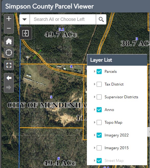
An example (Figure right) is the Simpson County Parcel Viewer. Find the Layer List and choose what you want on your map. Print the map to pdf for a digital copy or to your printer for a paper copy.
Mississippi still has some rural counties that do not offer on-line land roll information. In this case, a phone call or visit to your County Clerk may provide what you need.
On-X Hunt
You may find this app very useful. On-X Hunt provides consistent parcel information across the U.S. This software works on computers, tablets, and cell phones.
-
- Layer Source Name: On-X Hunt – Cost for Premium Hunt for one state (like Mississippi) is approx. $30/year.
- Description: Color-coded public and private land ownership boundaries allow you to easily find property lines for private and public property. Land ownership information includes names and tax addresses. On-X has an off-line map option for field use.
- For a free trial: https://huntsmarter.app.link/pSGvFQ6nyGb
LandGlide
This is a GPS property line mapping app that many foresters use. This app gives parcel data and property line location on your mobile device or computer. Nationwide coverage for $100/year.
For a free trial: https://landglide.com/
Create a Shapefile for your property
Many geospatial tools will be able to use the shapefile and/or KML file you create here. Before starting, become familiar with the boundary lines of your property (see section 1 above).
- Layer Source Name: MapMyProperty (Texas A&M University)
- Description: An outline of your property can be saved and used by many other applications.
- Use Custom Draw to draw the border of your property. When satisfied click on Area (Figure A).
- Save your MapMyProperty outline on your computer. Save your outline twice. Once as a .KML file and once as a .SHP or ESRI type shapefile (Figure B).
- The initial .SHP file will be compressed or zipped, MapMyProperty_SHP_Areas.zip. To use this compressed file, first Extract All items (Figure C) and place the extracted file on your computer in a folder of your choice.
Figure A. 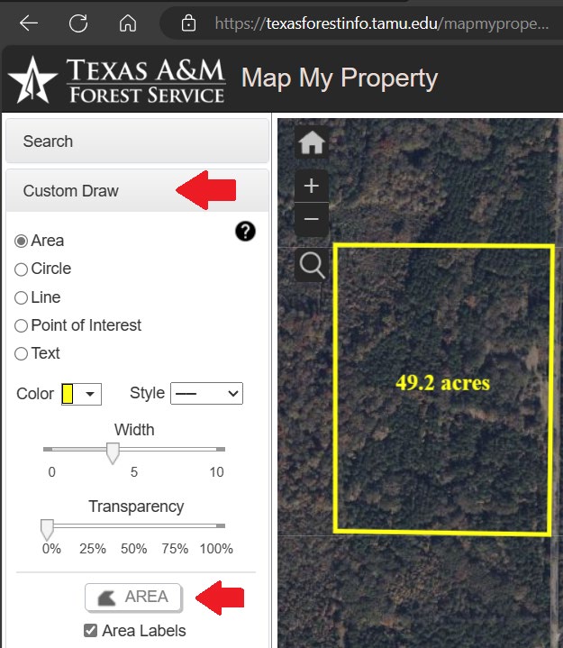 Figure B.
 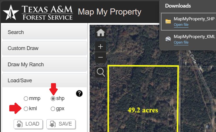 Figure C.
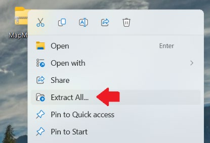
- Layer Source Location: https://texasforestinfo.tamu.edu/mapmyproperty/
2. Soils Maps and Information
-
Layer Source Name: Web Soil Survey (USDA NRCS)
-
Description: Soil data and information produced by the National Cooperative Soil Survey. The website is operated by the USDA Natural Resources Conservation Service (NRCS) which provides access to a tremendous amount of natural resource information. Below are descriptions on how to generate some of the more useful maps and tables for forest landowners.
-
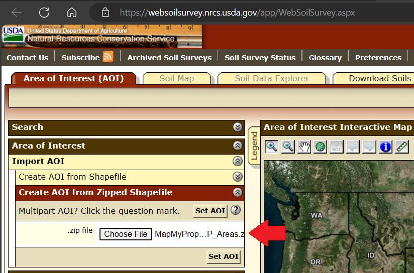
On the left-hand side choose Area of Interest (Figure below). Under that option select Create AOI from Zipped Shapefile.

-
Choose File – use the extracted MapMyProperty.shp file.
-
Set AOI.
Soils Map
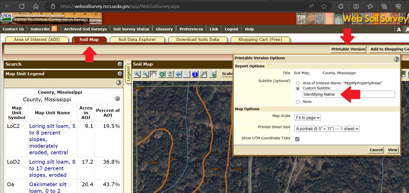
Locate the Soil Map tab right of the AOI tab (Figure below). Click the soil map tab, then printable version. Add an identifying name and click view. You may print the Soil Map as a pdf or as a paper copy.
Soil Drainage Classes
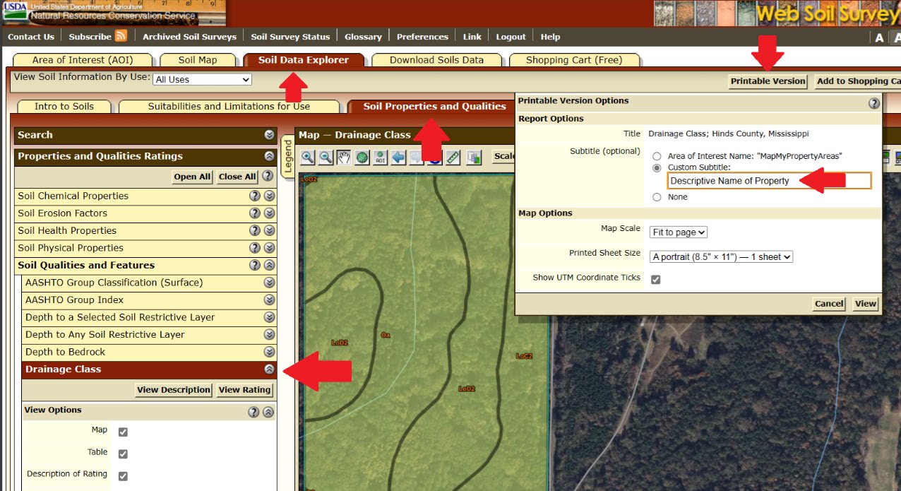
Seven classes of natural soil drainage are recognized: excessively drained, somewhat excessively drained, well drained, moderately well drained, somewhat poorly drained, poorly drained, and very poorly drained (Figure below). This generates a map and table. Drainage classes can guide your tree planting and help you match the best species to site.
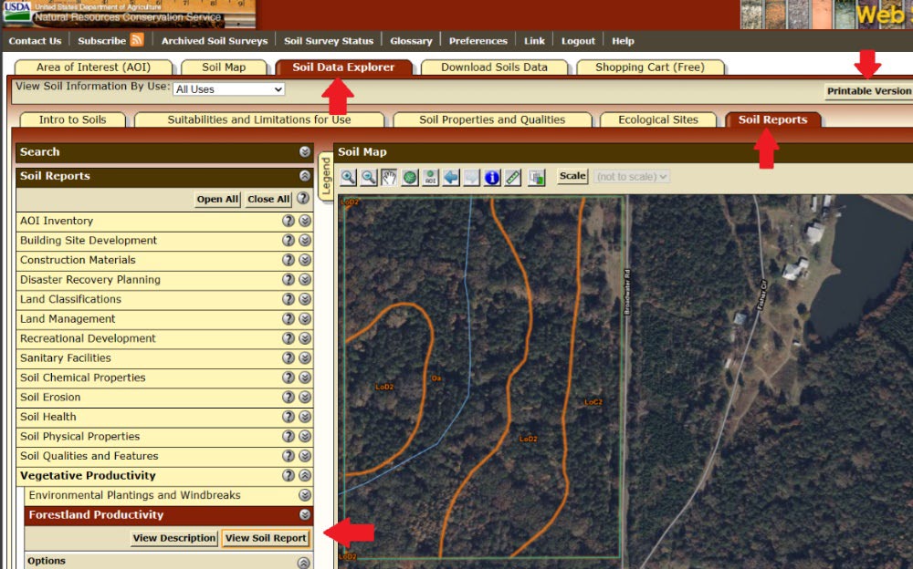
Forestland Productivity
A report on the suitability of soils for growing commercial timber species. Table shows common species with site index and average productivity in natural stands. Find the Soil Data Explorer tab and then the Soil Reports tab. Under the Vegetative Productivity on the left-hand side click on Forestland Productivity and printable version.
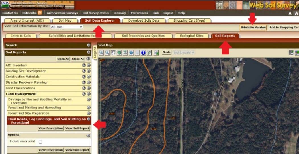
Haul Roads, Log Landings, and Soil Rutting
Soils are rated as Well, Moderate, and Poorly Suited for harvesting operations and the reasons why. To generate this report, find the Soil Data Explorer tab and then Soil Reports tab. Find Land Management along the left-hand side and under it Haul Roads, Log Landings, and Soil Rutting. Click on Printable Version.
- Layer Source Location: Web Soil Survey (usda.gov)
3. Stand Management Map
-
Layer Source Name: Google Earth Pro on desktop. Free for PC, Apple, or Linux.
-
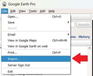
Description: Mapping tools that allow importing and exporting GIS information. The historical aerial imagery option allows you to look at property over time. Winter and summer imagery can help define boundaries of timber stands and approximate ages. Stand acreages and trail distances can be determined. Label and save work.
-
Import your property boundary using the MapMyProperty.kml file saved on your computer (Figure below).
-
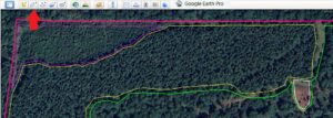
Use the polygon tab to delineate timber stands, ponds, and open areas (red arrow in Figure below). There are many color options. Trails and roads may also be added. Once completed, print a map.
- Layer Source Location: Earth Versions – Google Earth


4. Threatened and Endangered Species
Layer Source Name: U.S. FWS iPaC Information for Planning and Consultation
-
Description: iPaC generates a list of species for a particular property that are under US Fish and Wildlife Service (FWS) jurisdiction through the Endangered Species Act. Note: You do not have to log in or define a project. You may remain anonymous.
-
Listed species may be threatened, endangered, candidate, or proposed for listing. This list helps sharpen your focus when monitoring your property. If T&E species are found, considerations on how your management activities may affect T&E species may be needed.
-
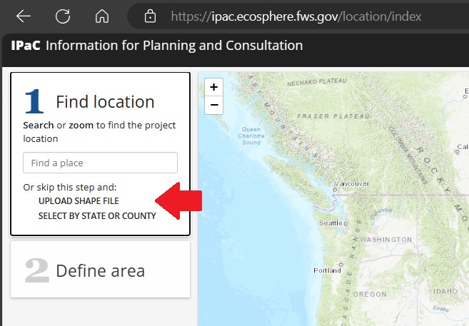
Upload the extracted MapMyProperty.shp shapefile, to define the area (Figure below).

-
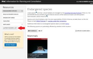
Review the thumbnail photos of T&E species and print these out as needed.
-
Click on Print Resource List (Figure below). This generates a report on the threatened and endangered species that could occur on your property. Print to .pdf or your printer.
-
Layer Source Location: https://ipac.ecosphere.fws.gov/

5. Wetlands
-
Layer Source Name: U.S. FWS iPaC Information for Planning and Consultation
-
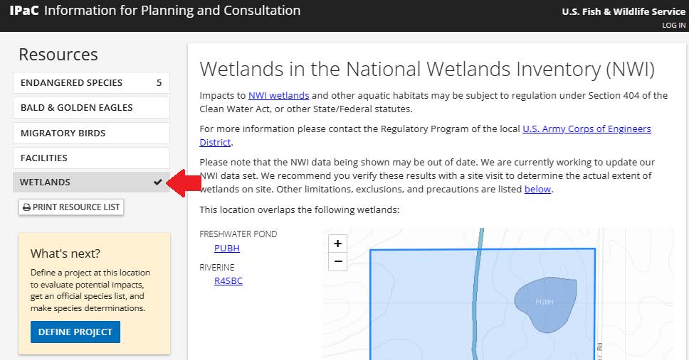
Description: A map of Wetlands in the National Wetlands Inventory located on your property (example below). Note: You do not have to log in nor do you have to define your project. You may remain anonymous.
-
Wetlands as defined USFWS may include drainages with distinct streambanks, ponds, and freshwater swamps, etc. Riverine or streambank location can guide the process of laying out streamside management zones to reduce non-point source pollution. Roads in swamps are special and may be subject to regulation under Section 404 of the Clean Water Act.
-
Click on the Wetlands resource button two or more times for it to work (Figure below). Three views are available: road map, aerial photo, or topo map. Adjust the view to see the vital information on the computer screen and then click Print Screen to capture. Print to .pdf or paper.

- Layer Source Location: https://ipac.ecosphere.fws.gov/
6. Forests of Recognized Importance (FORI)
-
Layer Source Name: FORI Mississippi
-
Description: Forests of Recognized Importance (FORI) represent globally, nationally, and regionally significant large landscape areas of exceptional ecological, social, cultural, or biological values (2021-2025 Standards of Sustainability for Forest Certification, ATFS).
-
Mississippi Forests of Recognized Importance or FORI were defined by the MS Tree Farm Committee. There are three designations: forestland adjacent to the National Forests of Mississippi, National Wildlife Refuges, or within the Ross Barnett Reservoir watershed.
- Layer Source Location: https://www.msforestry.net/page/TFResources
7. County Highway Maps (Access to Property)
-
Layer Source Name: Map Portal for MS Department of Transportation
-
Description: County highway maps provided by MDOT.
-
Download your county map. Expand and move the map to get your desired view on screen. Use Print Screen to capture the view. Use Paint or similar software to mark the property location and create a map showing road access to the property. Save a map as a .jpg or .png file.
- Layer Source Location: https://mdot.ms.gov/portal/
8. Cemeteries (Special Sites)
-
Layer Source Name: Cemeteries of Mississippi Counties
-
Description: County Highway Maps provided by Mississippi Department of Transportation with cemeteries highlighted.
-
Download your county map. Expand and move the map to view known cemeteries.
-
If you find a cemetery, use Print Screen to capture the view. Use Paint or similar software to save as a .jpg or .png file.
- Layer Source Location: http://msgw.org/maps/CountyCemeteries.htm
9. Historic Resources (Special Sites)
-
Layer Source Name: Mississippi Department of Archives and History, Historic Resources Inventory Map.
-
Description: The Historic Resources Inventory database is a compendium of information about Mississippi’s landmarks and architecture. This site offers basic information, such as construction date, architect, builder, National Register listing, and Mississippi Landmark designation.
-
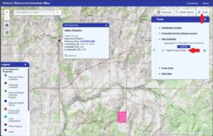
Click on Tools in the upper right-hand corner (Figure below). Add the MapMyProperty.shp shapefile to define the area to search.
-
The defined area will be pink. Expand and move the map to view the area surrounding the property. Click on any national, state, or local designated properties for more information.
-
When the map on screen is how you want it, tap Print Screen to capture. Use Paint or similar software to crop and save as a .jpg or .png file.
- Layer Source Location: Historic Resources Inventory Map ms.gov

10. Loblolly Pine Plantation Harvest Scheduling
-
Layer Source Name: TimberYield (Texas A&M Texas Forest Service)
-
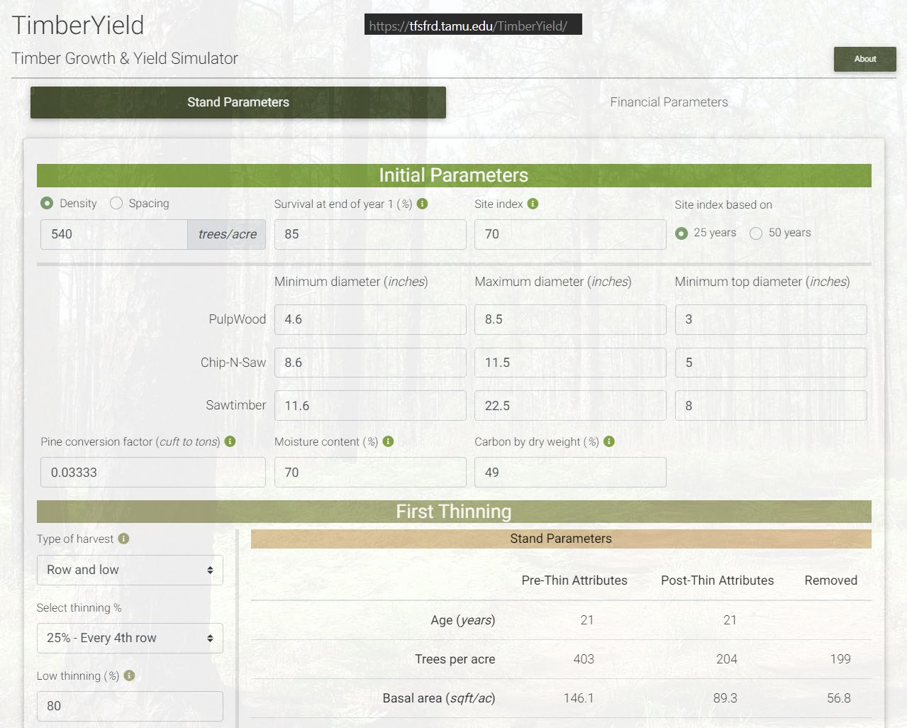
Description: TimberYield is a simple-to-use growth and yield simulator that has two screens — “Stand Parameters” and “Financial Parameters”. Each screen is arranged so that user inputs are listed in the left column and model outputs are listed in the right column. To get started, simply enter three basic variables: Planting density, Survival, and Site index. Defaults have been provided or input your own values.
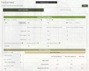
- Layer Source Location: https://tfsfrd.tamu.edu/TimberYield/